Understanding Myanmar's High Vulnerability to Earthquakes
Myanmar, a land of golden pagodas and rich cultural heritage, sits astride one of Asia's most active geological fault lines. While earthquakes are a natural phenomenon globally, tremors in Myanmar often seem to result in disproportionately severe consequences. Why is this nation so susceptible to earthquake damage? What complex interplay of geological fate and human factors contributes to the devastation witnessed during seismic events?
This post delves into the heart of Myanmar's seismic vulnerability. We'll explore the geological underpinnings that make the region prone to earthquakes, examine the historical context of seismic activity, and, most importantly, unpack the critical factors that amplify the destructive power of these tremors, leading to significant loss of life and property. Understanding these elements is crucial not only for comprehending past tragedies but also for shaping a more resilient future for Myanmar.
The Shaky Ground Beneath: Myanmar's Geological Hotspot
Myanmar's vulnerability to earthquakes isn't a matter of chance; it's deeply rooted in its geological location. The country is situated at a complex junction of tectonic plates, the massive slabs of Earth's crust whose movements shape our planet's surface and trigger seismic events.
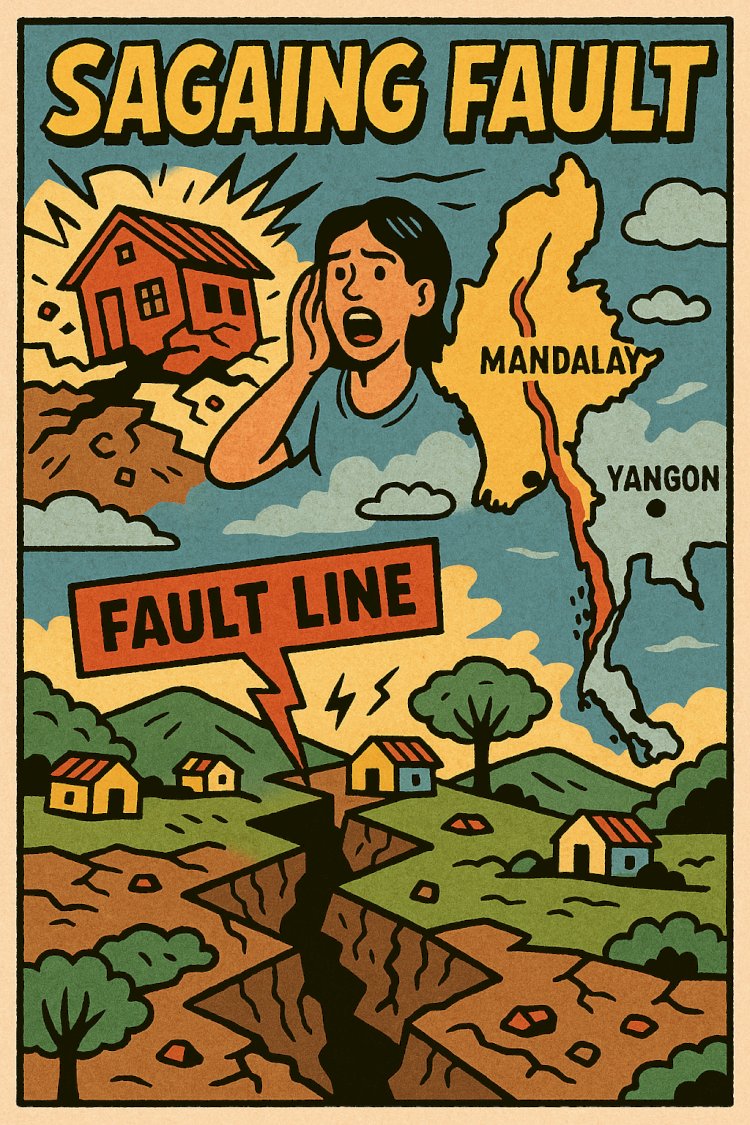
The Sagaing Fault: A Major Player
The most significant geological feature influencing Myanmar's seismicity is the Sagaing Fault. This major strike-slip fault runs north-south through the heart of the country for over 1,200 kilometers (about 750 miles), essentially slicing Myanmar in two.
- What is a Strike-Slip Fault? Imagine two giant blocks of land sliding horizontally past each other. That's the basic mechanism of a strike-slip fault. The Sagaing Fault accommodates the northward movement of the Indian Plate relative to the Sunda Plate (part of the larger Eurasian Plate).
- Stress Accumulation: As these massive plates grind against each other, immense stress builds up in the rocks along the fault line. When this stress overcomes the friction holding the rocks in place, the energy is released suddenly in the form of seismic waves – an earthquake.
A Convergence Zone
The Sagaing Fault isn't the only factor. Myanmar is caught in a broader zone of tectonic collision:
- Indian Plate: Moving northwards, colliding with the Eurasian Plate (responsible for the Himalayas further west).
- Eurasian Plate: The large continental plate to the north.
- Sunda Plate: A smaller plate southeast of Myanmar, which is influenced by the pressures from the larger plates.
This complex interaction means seismic activity isn't limited just to the Sagaing Fault itself, though it is the dominant source of large earthquakes within central Myanmar. Other smaller, associated faults crisscross the country, adding to the overall seismic hazard. This geographical lottery places major population centers, including historical capitals and modern cities like Yangon, Mandalay, and Naypyidaw, in close proximity to significant seismic threats.
A History Written in Tremors: Notable Earthquakes in Myanmar
Myanmar's history is punctuated by damaging earthquakes, serving as stark reminders of the ever-present risk. While comprehensive historical records are challenging, several significant events stand out:
- 1762 Arakan Earthquake: While centered offshore, this massive earthquake is believed to have caused significant coastal uplift and a devastating tsunami, highlighting the complex hazards facing the region.
- 1839 Ava (Inwa) Earthquake: This powerful earthquake largely destroyed the then-royal capital near Mandalay, demonstrating the vulnerability of major settlements along the Sagaing Fault.
- 1930 Bago (Pegu) Earthquake: A devastating magnitude ~7.3 earthquake struck near the city of Bago, causing widespread destruction and killing thousands. It was quickly followed by another major earthquake further north near Pyu.
- 1975 Bagan Earthquake: This magnitude 6.8 earthquake severely damaged many of the ancient temples and pagodas in the historic city of Bagan, a UNESCO World Heritage site.
- 2011 Shan State (Tarlay) Earthquake: A magnitude 6.8 earthquake near the border with Thailand and Laos caused significant damage and loss of life, particularly in the town of Tarlay.
- 2012 Thabeikkyin Earthquakes: A sequence of earthquakes, including a magnitude 6.8 mainshock, struck north of Mandalay, causing fatalities and damaging infrastructure, including bridges and monasteries.
- 2016 Chauk Earthquake: A magnitude 6.8 earthquake centered near Chauk in the Magway Region caused further damage to the temples of Bagan and resulted in several fatalities.
This history underscores that significant earthquakes are not rare anomalies but recurring events within Myanmar's geological timeline.
Why So Destructive? Key Factors Amplifying Earthquake Damage
While the geological setting explains why earthquakes happen in Myanmar, it doesn't fully explain why they often cause such heavy damage. Several compounding factors contribute to the heightened vulnerability:
1. Shallow Earthquake Focus Depths
Many earthquakes occurring along the Sagaing Fault and related structures in Myanmar happen at relatively shallow depths within the Earth's crust (often less than 20-30 kilometers deep).
- Impact: Shallow earthquakes are generally more destructive than deeper ones of the same magnitude. This is because the seismic energy has less distance to travel before reaching the surface. The waves lose less energy through attenuation (natural weakening as they travel through rock), resulting in much stronger ground shaking directly beneath the epicenter and surrounding areas. This intense shaking places immense stress on buildings and infrastructure.
2. Building Construction Standards and Practices
This is arguably one of the most critical factors influencing the scale of damage and loss of life.
- Lack of Earthquake-Resistant Design: Historically, and even in many contemporary constructions, formal earthquake-resistant design principles have not been widely implemented or enforced, particularly outside major modern developments.
- Vulnerable Materials: Traditional and common construction methods often rely on materials highly susceptible to collapse during strong shaking. Unreinforced masonry (brick or stone walls without steel reinforcement), adobe, and poorly constructed timber frames offer little resistance to lateral (side-to-side) forces generated by earthquakes.
- Informal Settlements: Rapid urbanization has led to the growth of informal settlements, often built quickly with substandard materials and without engineering oversight, making them exceptionally vulnerable.
- Aging Infrastructure: Older buildings, bridges, and infrastructure, constructed before any modern seismic considerations, represent a significant risk. The damage to Bagan's ancient temples in multiple earthquakes highlights the vulnerability of even historically significant masonry structures.
- Enforcement Challenges: Even where building codes might exist on paper, consistent enforcement across the country, especially in rural or rapidly developing areas, can be a major challenge due to resource limitations, lack of trained personnel, and governance issues.
3. Population Density and Urbanization
As Myanmar's population grows and urbanizes, more people are concentrated in areas exposed to seismic hazards.
- Increased Exposure: Major cities like Yangon and Mandalay lie in seismically active zones. High population density means that when an earthquake strikes a populated area, more people and properties are directly exposed to the danger.
- Concentrated Risk: Urban centers concentrate not only people but also critical infrastructure (hospitals, schools, utilities, transportation networks). Damage to these facilities during an earthquake can cripple response efforts and have long-lasting societal impacts.
4. Secondary Hazards
Earthquakes rarely cause damage solely through ground shaking. Associated secondary hazards can significantly worsen the impact:
- Landslides: Myanmar's topography includes extensive hilly and mountainous regions. Intense ground shaking can trigger devastating landslides, burying villages, blocking roads, and hindering rescue and relief operations. This is particularly true during the monsoon season when slopes are already saturated.
- Liquefaction: In areas with loose, water-saturated sandy soils (common in river valleys and deltas), strong shaking can cause the soil to temporarily lose its strength and behave like a liquid. This phenomenon, called liquefaction, can cause buildings to tilt or sink, underground pipes and tanks to float upwards, and ground surfaces to crack and subside.
- Fires: Broken gas lines and electrical shorts caused by shaking can ignite fires, which can spread rapidly in densely built areas, especially where water mains are also damaged, hampering firefighting efforts.
5. Socio-Economic Factors and Resilience Capacity
The underlying socio-economic conditions within Myanmar also play a role in its vulnerability and ability to cope with disasters.
- Poverty and Resources: Limited economic resources at both household and national levels can hinder investment in safer construction, preparedness measures (like earthquake drills or emergency kits), and post-disaster recovery efforts.
- Awareness and Education: Public awareness about earthquake risks and safety measures may be limited in some areas, affecting individual and community preparedness.
- Emergency Response Infrastructure: The capacity for rapid and effective search and rescue, medical response, and provision of shelter and aid can be stretched thin, particularly in remote or difficult-to-access regions impacted by an earthquake. Communication breakdowns and infrastructure damage further complicate response efforts.
- Governance and Institutional Capacity: Strong institutions and effective governance are essential for developing, implementing, and enforcing building codes, land-use planning regulations, and comprehensive disaster risk reduction strategies. Challenges in these areas can impede progress in building long-term resilience.
Building Resilience: Preparedness and Mitigation Efforts
Recognizing the significant risk, efforts are underway, often supported by international partners, to improve Myanmar's earthquake resilience, though challenges remain:
- Seismic Monitoring: Efforts exist to improve the network of seismometers to better monitor seismic activity and understand fault behavior, which can inform hazard assessments. The Myanmar Earthquake Committee and the Department of Meteorology and Hydrology play roles in this.
- Building Code Development: Steps have been taken to develop and update national building codes with improved seismic provisions, although widespread adoption and enforcement remain hurdles.
- Public Awareness Campaigns: Initiatives aim to educate the public, particularly schoolchildren, about earthquake safety measures ("drop, cover, hold on") and preparedness.
- Retrofitting: Identifying and strengthening critical vulnerable buildings (like hospitals and schools) is a key, albeit expensive, mitigation strategy.
- Disaster Risk Reduction (DRR) Planning: Integrating earthquake risk into broader national and local development planning is crucial for long-term resilience.
- International Collaboration: Collaboration with international organizations and experts provides technical assistance, capacity building, and resources for research and mitigation projects.
The Enduring Challenge
Myanmar's high vulnerability to destructive earthquakes stems from a potent combination of unavoidable geological circumstances and modifiable human factors. The active Sagaing Fault and the region's complex tectonics guarantee future seismic events. However, the severity of their impact is heavily influenced by the way communities build, where they live, and their capacity to prepare for and respond to these inevitable tremors.
While the ground beneath Myanmar will continue to shift, understanding the factors that turn tremors into tragedies is the first step towards building a safer, more resilient future for its people. The cost of inaction is measured in lives lost and communities shattered – a price too high to ignore.
What's Your Reaction?